Today in Réguisheim, rain and snow perturbation: It will only affect the region in the first half of the day.
Temperatures will vary between 0 and 4°C, it will be cold in the morning and with values close to normal.
The reliability of the situation is good.
This morning
0°Feels Like -3°due to the wind
Gusts 35 km/hS 20 km/h
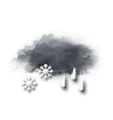
Overcast sky.
Snow showers followed by rain.
Risk of snow
100 %
UV index0Low
Fresh snow0.4 cm
This afternoon
4°Feels Like 0°due to the wind
Gusts 45 km/hS 25 km/h
Overcast sky.
Risk of a few drops of rain.
Risk of rain
40 %
UV index0Low
This evening
4°Feels Like 0°due to the wind
Gusts 35 km/hS 20 km/h
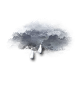
Overcast sky.
Light rain.
Risk of rain
90 %
Night
8°Feels Like 2°due to the wind
Gusts 70 km/hSW 40 km/h
Very cloudy to overcast sky.
Rain followed by showers.
Risk of rain
90 %
Share
CLIMATE info
Rain
-75%
normal
Less rain than normal
Water restriction: No restrictions
Temperature
0°C
normal
Temperature near normal
Normal temperature : 2°C
Average, today :
2°C
One year ago : 9°C