See all results
Your
favorites
édition
Become a V.I.P
Log in
Weather
Canada
Radar
Mountain
World
Weather
France
Northern Alps
Autrans (ski resort)
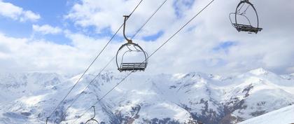
WEATHER SKI RESORT AUTRANS
38880 - Isère - France
Fri
28
8°
4°
Sat
29
4°
2°
Sun
30
8°
0°
Mon
31
10°
1°
Tue
01
-
-
Wed
02
-
-
Thu
03
-
-
Fri
04
-
-
Sat
05
-
-
Sun
06
-
-
Mon
07
-
-
Tue
08
-
-
Wed
09
-
-
Thu
10
-
-
Fri
11
-
-
+
Day
Time / Hour
Compare
Today's Forecast
Forecast produced by
Cyrille DUCHESNE
Updated at
12h30
- Next update at
17h45
(local time)
In Short
1/5
Ski resort info
Follow the weather
live
Hour by hour
Weather comparator
Infos Climat
Expert’s summary
This afternoon in Autrans, Very cloudy. No precipitation.
Temperatures will vary between 4 and 8°C.
The reliability of the situation is good.
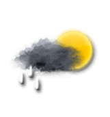
This afternoon
8°
Feels Like 9°
Gusts
45 km/h
NW 20 km/h
Very cloudy sky with short sunny periods.
No precipitation.
No risk of rain
UV index
2
Low
Freezing level 0°
1650 m
Snow-rain limit
1350 m
Fresh snow
0 cm
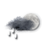
This evening
5°
Feels Like 2°
due to the wind
Gusts
50 km/h
N 15 km/h
Very cloudy sky with short clear periods.
Showers followed by rain.
Risk of rain
80 %
Freezing level 0°
1650 m
Snow-rain limit
1350 m
Fresh snow
0 cm
Night
3°
Feels Like 0°
due to the wind
Gusts
50 km/h
N 20 km/h
Overcast and misty. Limited visibility.
Rain.
Risk of rain
85 %
Freezing level 0°
1450 m
Snow-rain limit
1150 m
Fresh snow
0 cm
Tomorrow's weather
Weekend weather
Share
Link copied
Station Info
open
Autrans
Avalanche Risk
1/5 - Low risk
Snow
40 cm
at the top (1710m)
20 cm
down (1050m)
Snowfall
1 month ago : 2 cm
3 months ago : 50 cm
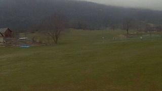
Webcam
Autrans - Village
Autrans - Village
Track Info
Lifts
7/18
Snow Parks
N.C.
Nordic ski
35/114 km
Back skiing
N.C.
Open tracks
3
15
2
10
2
11
1
4
with
CLIMATE info
Rain
+30%
normal
More rain than normal
Water restriction:
No restrictions
Temperature
+2°C
normal
Warmer than normal
Normal temperature : 4°C
Average, today : 6°C
One year ago : 5°C
Drought
0
/5
No drought
Fire-risk indicator
Risk Low
Ephemeris
Friday 28 march
Day
+3 min
Waning
crescent Moon
Sunrise
06h25
Sunset
19h00
Gontran
Next few days
Tomorrow,
Saturday 29
2°
|
4°
70
km/h
Sunday 30
0°
|
8°
60
km/h
Monday 31
1°
|
10°
55
km/h
Points of interest
arround Autrans
Natural sites
Pas de Montbrand
Pas de Pierre Taillée
Pas du Mortier
Near
Autrans
Autrans
Saint-Gervais
Passage du Versoud
Pas de la Porte
Rovon
La Rivière
Pas de Pertuson
L'Albenc
Col de Montaud
Poliénas
Chantesse
Col de Romeyère
Weather France
Lyon
Marseille
Nice
Paris
Toulouse
Rouen
Saint-Sulpice-de-Royan
Saint-Brieuc
Saint-Étienne
Saint-Lô
Saint-Malo
Saint-Martin-de-Ré