Today in Col du Feu, rain and snow will affect the region.
Temperatures will vary between -4 and 1°C, it will be cold in the morning.
The reliability of the situation is good.
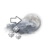
3:00 to 6:00
-4°Feels Like -6°
Gusts 30 km/hS 15 km/h
Clear periods and passing clouds, sometimes heavy.
Snow showers.
Risk of snow
20 %
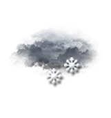
This morning
-4°Feels Like -6°
Gusts 40 km/hS 15 km/h
Overcast sky.
Snow showers turning to rain.
Risk of snow
100 %
UV index0Low
Fresh snow3 cm
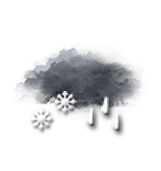
This afternoon
1°Feels Like -2°due to the wind
Gusts 45 km/hS 20 km/h
Overcast sky.
Snow showers followed by rain.
Risk of snow
90 %
UV index0Low
Fresh snow0.1 cm
This evening
2°Feels Like -2°due to the wind
Gusts 65 km/hS 25 km/h
Overcast sky.
Rain.
Risk of rain
90 %
Night
3°Feels Like -3°due to the wind
Gusts 80 km/hS 35 km/h
Overcast sky.
Rain followed by showers.
Risk of rain
90 %
Share
CLIMATE info
Rain
-80%
normal
Less rain than normal
Water restriction: No restrictions
Temperature
-2°C
normal
Colder than normal
Normal temperature : 0°C
Average, today :
-2°C
One year ago : 4°C