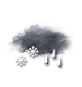
This afternoon in Col de Chalufy, Overcast and misty, reduced visibility. Rain followed by snow.
Temperatures will vary between -6 and 2°C.
The reliability of the situation is relatively good.
This afternoon
2°Feels Like 0°
Gusts 30 km/hCalm
Overcast and misty. Limited visibility.
Rain followed by snow.
Risk of rain
100 %
UV index1Low
Fresh snow7 cm
This evening
-5°Feels Like -7°
Gusts 20 km/hW 10 km/h
Low cloud settling as fog.
Snow showers clearing later.
Risk of snow
65 %
Fresh snow2 cm
Night
-8°Feels Like -10°
Gusts 25 km/hNW 10 km/h
Very cloudy sky with short clear periods.
Warning: conditions favourable to black ice.
Risk of snow
20 %
Share
CLIMATE info
Rain
-60%
normal
Less rain than normal
Water restriction: No restrictions
Temperature
-3°C
normal
Colder than normal
Normal temperature : 1°C
Average, today :
-2°C
One year ago : 2°C