Today in Col de Grataux, rain and snow perturbation: It will only affect the region in the first half of the day.
Temperatures will vary between 1 and 4°C, it will be cold and with values close to normal.
The reliability of the situation is good.
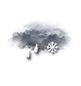
This morning
1°Feels Like -1°due to the wind
Gusts 60 km/hW 10 km/h
Very cloudy sky turning overcast.
Light sleet.
Risk of rain
90 %
UV index0Low
This afternoon
4°Feels Like 4°
Gusts 40 km/hSW 10 km/h
Very cloudy sky becoming more unsettled.
Risk of showers.
Risk of rain
40 %
UV index1Low
This evening
2°Feels Like 0°due to the wind
Gusts 35 km/hS 10 km/h
Unsettled weather becoming very cloudy.
Warning: conditions favourable to black ice.
No risk of rain
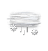
Night
1°Feels Like 0°
Gusts 35 km/hSW 10 km/h
Overcast sky.
Drizzle followed by snow.
Risk of snow
90 %
Fresh snow1 cm
Share
CLIMATE info
Rain
-45%
normal
Less rain than normal
Water restriction: No restrictions
Temperature
+1°C
normal
Warmer than normal
Normal temperature : 2°C
Average, today :
3°C
One year ago : 6°C