Today in Grong, danger: very violent gusts.
Temperatures will vary between 4 and 5°C, it will be cold in the morning.
The reliability of the situation is very good.
This morning
4°Feels Like -1°due to the wind
Gusts 115 km/hW 35 km/h
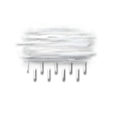
Overcast sky.
Drizzle clearing gradually.
Risk of rain
90 %
Freezing level 0°
1150 m
Snow-rain limit
800 m
Fresh snow
0 cm
This afternoon
5°Feels Like 0°due to the wind
Gusts 115 km/hW 35 km/h
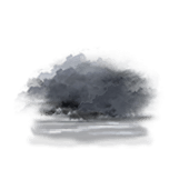
Overcast sky.
Rain.
Risk of rain
90 %
Freezing level 0°
1250 m
Snow-rain limit
850 m
Fresh snow
0 cm
This evening
5°Feels Like 1°due to the wind
Gusts 100 km/hW 25 km/h
Low cloud settling as fog.
Risk of a few drops of rain.
Risk of rain
30 %
Freezing level 0°
2150 m
Snow-rain limit
1850 m
Fresh snow
0 cm
Night
5°Feels Like 2°due to the wind
Gusts 65 km/hW 20 km/h
Fog, giving way to low cloud.
No precipitation.
No risk of rain
Freezing level 0°
1250 m
Snow-rain limit
950 m
Fresh snow
0 cm
Share
Station Info
open
Grong
Avalanche Risk
N.C.
Snow
30 cm
at the top
(700m)
N.C.
down
(225m)
Snowfall
10 days ago : 2 cm 12 days ago : 8 cm 9 months ago : 3 cm