Home
Radar
My account
Home
Canada
Radar
Mountain
World
My account
Log in
Contact us
search.title
See all results
more.result.label
more.result.btn
geoloc.title
historical.title
remove.histo.label
favorite.title
edit.favorite.label
restrict.login.label
Log in
Weather
United States
Bretton Woods (ski resort)
WEATHER BRETTON WOODS
United States
Mon
05
-
-
Tue
06
-
-
Wed
07
-
-
Thu
08
-
-
Fri
09
-
-
Sat
10
-
-
Sun
11
-
-
Mon
12
-
-
Tue
13
-
-
Wed
14
-
-
Thu
15
-
-
Fri
16
-
-
Sat
17
-
-
Sun
18
-
-
Mon
19
-
-
+
Day
Time / Hour
Compare
Today's Forecast
Forecast produced by
Alexis VANDEVOORDE
Updated at
19h00
- Next update at
01h15
(local time)
In Short
N.C.
Ski resort info
Weather radar
Hour by hour
Weather comparator
Expert’s summary
Tonight in Bretton Woods, Overcast and misty, reduced visibility. Light snowfalls.
Temperatures will vary between -11 and -10°C, it will be very cold.
The reliability of the situation is good.
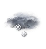
21:00 to midnight
-11°
Feels Like -12°
Gusts
25 km/h
Calm
Overcast and misty. Limited visibility.
Light snow showers.
Risk of snow
90 %
Freezing level 0°
0 m
Snow-rain limit
0 m
Fresh snow
1.5 cm
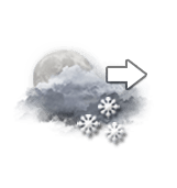
Night
-11°
Feels Like -12°
Gusts
20 km/h
Calm
Very cloudy sky becoming more unsettled.
Snow showers clearing later.
Risk of snow
55 %
Freezing level 0°
0 m
Snow-rain limit
0 m
Fresh snow
< 1cm
Tomorrow's weather
Weekend weather
Receive the weather forecast for my ski resort
Share
Link copied
Station Info
open
Bretton Woods
Avalanche Risk
N.C.
Snow
121 cm
at the top (945m)
45 cm
down (488m)
Snowfall
3 days ago : 2.54 cm
5 days ago : 2.54 cm
6 days ago : 5.08 cm
Track Info
Lifts
8/9
Snow Parks
1/1
Nordic ski
19/100 km
Back skiing
N.C.
Open tracks
24
25
33
40
21
25
6
10
with
Ephemeris
Monday 5 january
Day
+1 min
Waning
gibbous Moon
Sunrise
07h19
Sunset
16h23
Simeon Stylites
Next few days
Tomorrow,
Tuesday 06
-
|
-
-
-
km/h
Wednesday 07
-
|
-
-
-
km/h
Thursday 08
-
|
-
-
-
km/h
Near
Bretton Woods
Bretton Woods
Crawford notch
Carroll
Cannon Mountain (ski resort)
Bethlehem
Mount washington
Loon Mountain (ski resort)
Franconia
Pinkham notch
Whitefield
Lincoln
Bartlett
Weather United States
Los Angeles
Washington D.C.
San Francisco
New York
Chicago
Fresno
Newark
Buffalo
Chandler
Gilbert
Glendale
Mesa